Article content
Whether travelling by car, bus or train, commuters had to deal with the havoc brought on by one of the winter’s biggest storms on Thursday, after about 14 centimetres of snow and 12 millimetres of rain fell on Ottawa and the surrounding region over 24 hours.
While Environment Canada lifted its snowfall warning by mid-afternoon, agency meteorologist Gerald Cheng said more messy spring weather was on the way.
Advertisement 2
Story continues below
Article content
Article content
During the morning commute, the Ottawa Police Service said more than 28 collisions had been reported as of about 9 a.m. By the time of the late-afternoon commute, that number had already risen to more than 90, about three times more collisions than an average day.
Renée Amilcar, the general manager of OC Transpo, said in a memo to Ottawa’s mayor and city councillors that the wet snow and a sudden temperature drop could have been the causes of a stopped train on the Confederation Line around 6:10 a.m.
Amilcar said a “technical issue” led a westbound train to stop near Bayview Station.
“When the operator could not resolve it, technicians were dispatched for further troubleshooting. During this time, Line 1 continued to operate with single-track service between Tunney’s Pasture and Lyon stations. Customers were required to transfer at Lyon Station to continue their trips,” the memo said.
The train was removed from the line, and full service resumed around 9:30 a.m., Amilcar said. Rideau Transit Maintenance, which oversees LRT system maintenance, was investigating, she added, and initially believed the weather “may have impacted the affected train’s communications-based train control system.”
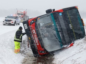
Meanwhile, paramedics confirmed they were called to a crash Thursday morning after an OC Transpo double-decker bus slid into a ditch on Frank Kenny Road in the Navan area. One man was treated at the scene for minor injuries.
Amilcar said the bus operator reported the crash shortly after 6:40 a.m. No passengers were aboard and no other vehicles were involved, she said.
Advertisement 3
Story continues below
Article content
The storm also left a layer of heavy, wet snow on sidewalks and lawns.
School buses continued to run in Ottawa, according to the Ottawa Student Transportation Authority, although delays due to road conditions were to be expected.
However, some rural regions in Eastern Ontario reported buses were cancelled for some schools.
While thousands were hit by power blackouts overnight, by Thursday afternoon Hydro Ottawa was reporting only scattered outages affecting a few dozen customers.
Outside the national capital, though, Hydro One reported thousands were without power in eastern Ontario.
Cheng, the meteorologist with Environment and Climate Change Canada, said the storm may have come as a surprise to some after a relatively dry early spring, but it’s not out of the ordinary. In March, about 39 millimetres of rain fell in Ottawa, about half the average monthly total. As for April, Ottawa typically receives about 12 centimetres of snow in total.
“So, expect snow,” he said. “Snow is not done. Don’t put away the shovels yet, don’t put away the snow boots yet.”
While the bulk of snow had fallen by Thursday afternoon, when the weather agency lifted the snowfall warning, about two to four centimetres more was in the forecast as part of a “messy mix” of showers and flurries heading into the weekend. Temperatures will rise, with Friday’s high expected to be around 5 C.
Advertisement 4
Story continues below
Article content
The temperature was expected to remain right around the freezing mark on Thursday night, Cheng said.
The forecast for Saturday includes mixed skies with a high near 8 C, while Sunday should be sunny with a high temperature of 14 C, meaning the snow likely won’t stick around.
This April storm came courtesy of a Colorado low, Cheng said, describing a low-pressure system that first formed in Colorado, absorbing warmth and moisture from the Gulf of Mexico. “The warmth and moisture clashed with Arctic air from the Prairies,” he said, which was why the storm system was “very potent, or severe, when it came our way.”
Recommended from Editorial
PHOTOS


Article content


Comments