A rainfall warning bringing 50 to 100 millimetres of rain continues to be in effect for Ottawa-Gatineau and eastern Ontario this Friday, as the remnants of Debby move across the country.
Environment Canada says on its website “a low pressure system interacting with the remnants of tropical storm Debby is expected to give heavy rainfall for eastern Ontario” Friday.
Environment Canada says while the system passes through Southern Ontario and Quebec Friday, communities between Cornwall, Ont., through Quebec City are prone to the the risk of flash flooding. The agency has also warned that minor landslides are a possibility.
Residents are asked to familiarize themselves with information about flooding by consulting their local Conservation Authority or Ontario Ministry of Natural Resources and Forestry by visiting the following website: Ontario.ca/floods.Tropical Storm Debby continued to swirl over Georgia and Carolinas on Wednesday. Some coastal cities have received more than 30 cm of rain.
- Have you experienced flooding at your home due to the rain or seen flooding on a street in Ottawa? CTV’s Natalie van Rooy would like to speak to you for a story – please email natalie.vanrooy@bellmedia.ca
“Even without Debby, the system would’ve brought us some rain tomorrow,” David Phillips, senior climatologist for Environment Canada, told CTV News Ottawa Thursday.
“But now with the abundance of precipitation or moisture from Debby, we’re going to see significant rain.”
Phillips says Friday’s heavy downpours could be record-breaking.
The current record for most rain on Aug. 9 is 41.4 mm, set in 1959.
“Ottawa is used to tornadoes, but we don’t often see remnants of hurricanes in the Ottawa area,” Phillips added.
The weather agency is expecting the rain to taper off later this evening.
The remnants of Debby are expected to reach New Brunswick Friday night and dump up to 40 millimetres of rain through Saturday morning.
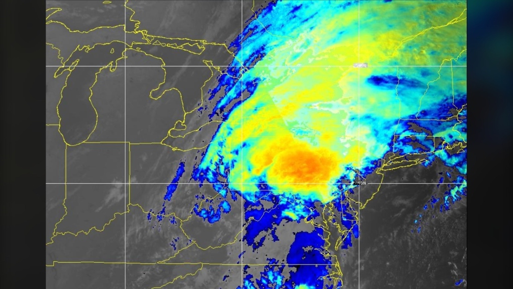 Post-tropical Cyclone Debby is seen in an RGB image from the National Oceanic and Atmospheric Administration, captured at approximately 5:30 a.m. on Friday, Aug. 9, 2024.
An amount of 13.7 mm of rain has been received at the Ottawa Airport, as of 8 a.m.
The weather station at the Central Experimental Farm has recorded 29.6 mm of rain, as of 10 a.m.
Cornwall area has received 50-75 mm of rain since early Friday morning, says Environment Canada.
Weather forecast
A high of 22 C, heavy rain and a risk of thunderstorm are in the forecast for Friday in Ottawa. The capital is expected to receive 50 to 70 mm of rain today. The rain is expected to end after midnight – risk of a thunderstorm this evening and after midnight. A low of 15 C and 5 to 10 mm of rain are in the forecast for the night, according to Environment Canada.
A high of 25 C and a 30 per cent chance of rain are in the forecast for Saturday. Clear skies and a low of 13 C are forecasted for the night.
A high of 21 C and a 40 per cent chance of showers are forecasted for Sunday. A low of 14 C and a 40 per cent chance of showers are forecasted for the night.
The average temperatures for this time of year are a high of 25.8 C and a low of 14.9 C. The average monthly frequency of precipitation for August is 35 per cent.
With files from The Canadian Press